We are competent, unique and always here for you. Connect with us now.
Road Intelligence Software Suite: Road Control Tower
TigernixRCT: A highly intelligent Command & Control center utilising Industry 4.0 to improve road transportation through seamless coordination, data-driven insights, and unified visualisation for enhanced safety, asset management, and strategic planning.

Road Intelligence Software Suite:
Road Control Tower
Tigernix Road Control Tower (TigernixRCT) is a highly intelligent Command & Control centre that facilitates seamless coordination and data-driven decisions through advanced Industry 4.0 capabilities, improving each transportation aspect from traffic safety and assets to strategic road infrastructure planning under a singular video wall.
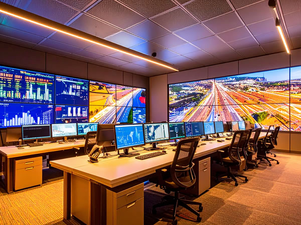
TigernixRCT- An Advanced Command Console for Transportation Governance
Experience universal transportation intelligence in one room now. Tigernix all-in-one smart control dashboard employs Industry 4.0 digital capabilities such as AI, Digital Twin, GIS, Satellite, IoT, advanced analytics, etc., to synchronise all transport data into a centralised decision-making ecosystem unlike any traditional control system.
TigernixRCT functions through these five stages to offer data-driven insights at the last point.
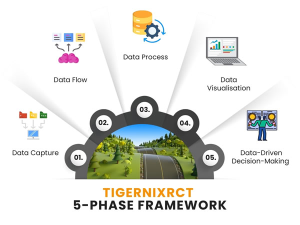
TigernixRCT’s 5-Stage Blueprint
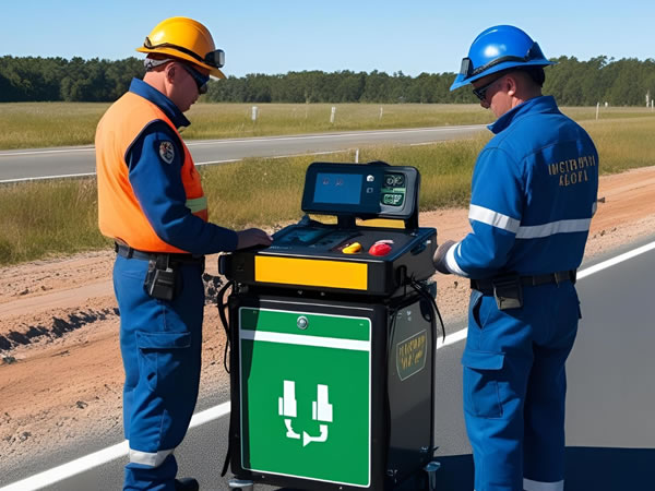
TigernixRCT receives data via mobile and GPS-based fleet tracking systems, Weather Monitoring Stations, ANPR, CCTV, WIM, GPS, telematics data, BIM, Drones, Aerial Imaging, Crowdsourced Mobile Apps, SHM, Load, Pressure, Roadside networks, GPR, LiDAR, Crack Detection Cameras, Drones, etc.
TigernixRCT integrates with APIs such as Google Maps Traffic, HERE Location Services, TomTom Traffic, OSM, TransitFeeds, INRIX Traffic Intelligence, Microsoft Azure Maps, as well as robust middleware platforms that vary from Apache Kafka, MuleSoft Anypoint, and Apache NiFi to Node-RED, etc., to process data.
It connects with data processing technologies such as Cloud Computing, AI, GIS, GNSS, 5G, Computer Vision, Predictive & Prescriptive Analytics, Big Data, Real-Time Stream Processing, Blockchain, API integration frameworks, CPS, sensor fusion, NLP, Simulation Modelling Tools etc., to enhance clarity.
The control console visualises data via digital methods such as Smart Dashboards, Heat Maps, Live Traffic Flow Animations, Geospatial Maps with Asset Overlays, Real-Time Video Feeds, Simulation-Based Visual Models, Digital Twin Interfaces, Weather Impact Visual Forecasts, Road Condition Colour Coding, etc.
TigernixRCT consolidates live transport data streams into one central dashboard, helping decision-makers oversee road network health, manage urban traffic, schedule predictive maintenance, and align infrastructure investments with performance goals and long-term transportation strategies easily.
Capabilities of Tigernix
Road Control Tower
Road intelligence reaches new heights as Tigernix’s road control room compiles every aspect of road management, including inspection data, structural evaluations, real-time traffic flow, and regulatory alignment, into a central dashboard, making it easy for leaders to foresee, plan, and make data-driven decisions.
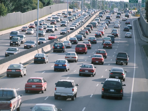
Traffic Analysis Zone
Solution
This road intelligence system consolidates all data related to traffic management, from incident detection and response, traffic signal and traffic patrol squad commanding, vehicle classification, congestion analysis, and route monitoring to violation detection and traffic flow analytics, etc., for further visualisation.
Capabilities
- Enabling data-driven policies through real-time traffic insights.
- Supporting strategic planning with AI-powered traffic forecasts.
- Centralising multi-source traffic data for informed infrastructure decisions.
- Visualising congestion patterns for smarter urban development via Digital Twin.
- Facilitating cross-agency coordination through Iot-driven unified control dashboard.
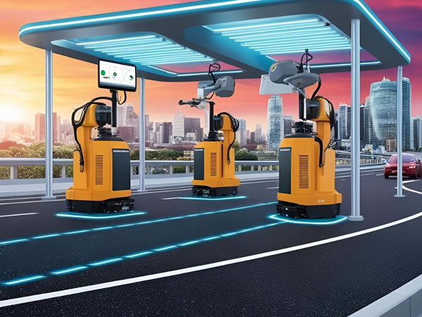
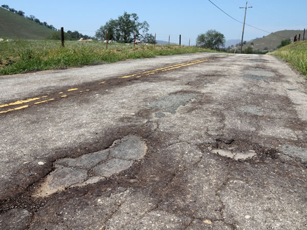
Smart Road Asset Management Panel
Solution
TigernixRCT gathers all data streaming down from road-related elements such as pavements, bridges, traffic signals, roadside infrastructure, road surfaces, potholes, guardrails, barriers, etc., onto a smart screen for the decision-makers to look into them remotely and get into data-driven decisions.
Capabilities
- Multi-asset synchronised monitoring in a unified view for further analysis.
- Providing high-resolution aerial diagnostics of remote or elevated infrastructure.
- Translating embedded sensor data into risk-weighted health indices.
- Crowdsourced surface damage detection using drones and smart vehicles.
- Geo-intelligent prioritisation of asset repairs, climate change and investment.
Incident, Accident, and Emergency Response Console
Solution
This Industry 4.0-driven road control & command post offers insights for visualising incident trends and response metrics on a smart dashboard that empowers top-level authorities to assess performance, allocate resources, and ensure compliance with emergency response protocols.
Capabilities
- Data-backed scenario analysis for faster executive-level emergency resource decisions.
- Offering live CCTV and sensor data visualisation and simulations for strategic decision insights.
- Comprehensive incident trend analysis for long-term emergency management planning.
- Centralised dashboard with actionable insights on crisis management outcomes.
- Predictive modelling for proactive disaster preparedness and resilience planning.
Smart Work Zone and Construction Management
Solution
Our digital control console takes care of AI-driven traffic management, optimising rerouting and minimising congestion in active work zones, while ensuring safety and compliance and providing decision-makers with immediate updates and visualisation for effective road construction planning.
Capabilities
- Predicts construction delays and adjusts timelines based on historical data.
- Offering real-time site inspections using drones and providing instant visual data.
- Satellite imagery integration for accurate project site mapping and progress.
- AI-driven simulation and visualisation tools for pre-construction planning.
- AI-compliance monitoring to ensure regulatory standards in construction zones.

Weather Impact Intelligence Station
Solution
TigernixRCT can provide insights into climate-influenced traffic flow anomalies using AI-powered pattern recognition, predictive analytics, and meteorological datasets to correlate adverse weather with congestion surges, enabling decision-makers to deploy dynamic rerouting protocols and adaptive traffic signal algorithms.
Capabilities
- Visualising rain severity using IoT sensors and predictive analytics models.
- AI, ML forecast weather disruptions, guiding strategic traffic management decisions.
- AI synthesises cross-hazard climate data for decision-grade scenario forecasts.
- Offering insights into coastal road vulnerabilities using satellite data combined with AI.
- Pinpointing high heat levels for surface integrity using embedded thermal sensors.
Data-Driven Road Investment Planning Zone
Solution
This smart console has the power to correlate congestion data with road wear patterns, enabling predictive maintenance planning and ROI scoring that empowers executives to make informed infrastructure decisions with minimal environmental and financial impact, all under one smart canopy.
Capabilities
- GIS mapping for capital investment gaps across national transport networks.
- Visualising national road health for executive planning through cloud dashboards.
- Giving a full-scale view of maintenance ROI evaluations for smarter fund allocation.
- Integrating big data for toll revenue with expenditure optimisation forecasts.
- Digital Twin simulations of funding outcomes under diverse investment scenarios.


Sustainability and Environmental Impact Monitoring Unit
Solution
Tigernix command centre can continuously monitor the sustainability of road networks, evaluating air quality, noise pollution, and runoff impacts with IoT and AI-driven algorithms, providing decision-makers with critical and back-to-back insights to guide green infrastructure development.
Capabilities
- Visualising environmental performance, enhancing transparency and decision-making.
- Geo-spatial analysis tools for accurate environmental impact mapping for effective land-use management.
- Dynamic climate change risk forecasting to reduce weather-related disruptions.
- Automated compliance tracking and ensuring environmental regulations are met.
- Integrating ESG metrics for sustainable procurement and resource allocation decisions.
Parking Management and Violation Detection
Solution
This advanced module provides strategic oversight of city-wide parking enforcement, integrating predictive analytics, drone surveillance of violations, ticket automation, and space optimisation tools, helping leaders reduce congestion and plan data-informed zoning and revenue models from one control room.
Capabilities
- Detecting recurring violations for targeted enforcement planning via ML algorithms.
- Visual-based smart zoning recommendations to optimise legislative parking frameworks.
- AI vision quantifying violation density for road & transportation policy optimisation.
- Using Geospatial dashboards to highlight enforcement gaps and inefficiencies instantly.
- Real-time recording and ensuring tamper-proof violation and citation records via Blockchain.

We gather all the Industry 4.0 digital powers to offer decision-makers a one-stop, ISO-certified executive dashboard for road and transportation management to ensure real-time visibility, enabling smarter, data-backed decisions for each aspect of roads under one smart authority support centre.
TigernixRCT: One Smart Command for Multi-Dimensional Road Supervision
Way to walk towards the smart road management & supervision with TigernixRCT! This is your unified control and command post powered by road intelligence and cutting-edge technologies, providing decision-makers with a holistic view of road and transportation networks from A to Z inside one digital space.
Data-Driven Decision-Making and Policy Formulation
Industry 4.0 technologies within this road intelligence control room deliver actionable insights by integrating real-time traffic, environmental, and infrastructure data, enabling decision-makers to create data-driven policies that optimise road networks, enhance safety, and improve sustainability.
Transparent Road Asset Accountability
Through real-time monitoring, AI-driven analytics, and predictive modelling, Tigernix road control room enables transparent road asset accountability, helping decision-makers manage infrastructure assets efficiently and align maintenance efforts with performance metrics and real-time conditions.
Centralised Control over All Transportation Assets
Industry 4.0-driven, our road intelligence control room offers a unified platform to manage transportation assets across geographical boundaries, using AI, IoT, and real-time analytics to ensure synchronised operations, strategic planning, and optimal decision-making.
Seamless Cross-Agency Integration
Integrated with road intelligence, our smart control room enables flawless cross-agency integration, using advanced data synchronisation, real-time analytics, and machine learning to connect transportation, law enforcement, and public service agencies for cohesive management and coordination.
Smart Road Investment Planning and Justification
Employing real-time data, AI, and IoT, we provide decision-makers with cost-efficient road investment modelling. With its embedded predictive analytics, investments are justified by concrete data, optimising both resource allocation and long-term infrastructure sustainability.
Holistic Road Safety Management
Tigernix road command post integrates data from local law enforcement, emergency responders, and road maintenance teams. This centralised information console empowers decision-makers to coordinate multi-agency responses, improving safety and reducing response times during critical incidents.